
Smart cities truly seem to be the future of humankind. Geospatial Data Collection can make every smart city project a sheer success.
The concept of Smart Cities is developing at a fast pace all over the globe. Such endeavors will offer an all-inclusive digital environment that not only enhances the security and efficiency of urban systems, but underpins the participation of citizens in rising urban developments. Depending upon the utilization of geospatial data, this concept includes concerns about urban services, urban built surroundings, and natural environment. Successful accomplishment of any smart city development is only possible with the building of a digital system that has the capacity of managing geospatial data in an environment that is user-friendly. With Geospatial Data Collection, we will be able to fabricate a technology platform that shapes the backbone of Smart Cities by mobile app development company.
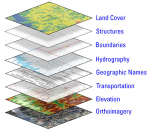
Geospatial applications
Geospatial solutions function by assisting Smart Cities in generating revenue via property taxes.
Data collection methods also include maintaining costs and optimizing various operations with accurate 3D maps for infrastructures and city roads.
Geospatial Data Collection even supports utilities to correctly layout and map their networks for the purpose of enhanced service deliveries.
The gamut of information that is acquired from 3D LiDAR supported mapping amalgamated with geospatial analytics will furnish designers and city planners with the key data collection tools for managing the complex challenges posed by urban environments.
Mapping of 3D City
- Generation of DTM and uncovered earth model from point cloud
- Utilizing processed point cloud data for the fabrication of 3D modeling of texturing & building
- Post-processing and merging of high-density movable LiDAR data from various capture solutions
- Grounding of utility map above the ground by utilizing point cloud data
- Building frontages & feature extraction from LiDAR point cloud data
Utilities Mapping
Data collection and analysis carried out in the shape of 3D point clouds and 360-degree panoramic images assists in accurate extraction of utility attributes that are geo-referenced. This is for crafting vector layers.
Utilities for the development of Smart Cities include water, telecom, electric, and gas. These utilities are habitually tasked with the collection of plant infrastructure data for custom inspection, engineering, abiding by safety standards, network planning, etc.
Surveillance & Security
- Vital installation planning within the city
- Traffic junction investigation for flow management
- Railway station exit & entry point survey
- Precise 3D capture of exit & entry points of markets, jetties, schools and important residential areas
- Planning and monitoring entry & exit points of all urban areas
Application of GIS in Smart City Planning
A technology for capturing, storing, manipulating, and analyzing spatially referenced data is regarded as GIS. Advantages of GIS applications in smart city projects are as follows:
- Smart cities are able to fabricate smart communities for analyzing and discovering issues for the local community
- Smart cities can recognize suitable representatives for local governance at a multi-level as a portion of self organizing policy
- Smart cities can enhance utilization of present infrastructure capacity which will then enhance life quality
- Smart cities truly seem to be the future of humankind. Geospatial Data Collection can make every smart city project a sheer success.
Join the conversation!